Ed. Note: I began writing professionally in 1975, so I have a lot of articles on file. Since news about the outdoors will be a little skimpy for the next two months – while Mother Nature takes her sweet time warming things up – I thought I’d pull a few pieces from the archives – or “the morgue” as they say in the newspaper business.
This first piece was penned on July 1, 1994 for publication in Virginia Outdoor Weekly
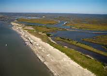
Our Beautiful Barriers
They dangle off the coast of Virginia like fluffy clouds of sand. Smith Island, Wreck Island, Cobb Island, Hog Island. From the southern tip of the Eastern Shore to Assateague, countless islands stand proud and unblemished, guarding the last remains of the unspoiled, natural beauty of the Atlantic coast. Paramore Island, Cedar Island, Metompkin, Wallops and many others form the beautiful Barrier Islands of Virginia.
Seashells grace the shorelines of these secluded places. Terns, egrets, and marsh hens are among the sentries guarding the grassy dunes. On the southern barrier islands, there are no gas stations, no condos, no 7-11s, no asphalt and no surfboards. It’s simply sand, grass, wildlife and overwhelming natural beauty.
Last week, it was my pleasure to explore the islands for the first times and to drift a few minnows for flounder as they moved into the rich feeding grounds out of Oyster.
Oyster, a tiny hamlet on the seaside of Virginia’s Eastern Shore, is a waterman’s town where crab pots are stacked high in most backyards. It’s also a port for big, steel clamming boats that dredge the soft sand of the Atlantic for sea clams, which are later processed back at the plant in Oyster.
One reason I have never explored the Barrier islands before now is that I’m a big chicken. I get lost sometimes in the grocery store and the thought of taking a wrong turn at Cobb Bay and ending up on the shores of western Africa has kept me fishing on the bayside, where I always knew where I was – or maybe usually knew where I was.
Taking a boat out of Oyster is a little like being an aquatic mouse in a marshy maze. You turn left at the red buoy marker and live. Turn right and you’re crab bait. And there are hundreds of those markers and buoys of life and death.
My friends at Cherrystone Campground, however, had convinced me that I could find my way around and through the markers to the hungry flounder. Their description, “hungry flounder”, got my attention.
My son, Jimmie, accompanied me on our maiden voyage in our 16-foot tri-hull into the Atlantic. A16-foot tri-hull into the Atlantic? Yep, it was easy as these protected waters are much calmer even than the bayside. All the islands and inlets combine to break the forces of wind and tide. It was like taking a boat ride on Buggs Island on a slightly windy afternoon.
While my son and I were pouring over a complicated map of the islands, trying to decide whether to go left or right to reach the hungry flounder, the Angel of the Lord did us one better – sending another boat ahead of us. We pulled behind this heaven-sent craft weaving in and out of the markers until we reached Buoy 224 near the Cobb Island Coast Guard Station.
There, we found the hungry flounder.
We fished for three days out of Oyster and only got lost twice and stuck once. FYI: If you see a red buoy coming back to port, don’t even think about being on the right side. Stay left. Always. Those buoys mean business.
But we caught flounder! More than we could possibly eat. Many were big fish, 18-inches or better. The seaside flounder went for a combination bait of a squid and a minnow with a pink skirt rigged above the hook.
In addition to flounder, we caught sea bass, trout, triggerfish, hogfish, spot and a jillion croakers.
If you can remember to keep the red markers on your left when you go out and always on the right when you return, you too can find the hungry flounder on the Barrier Islands and live to tell about it.